| |||||
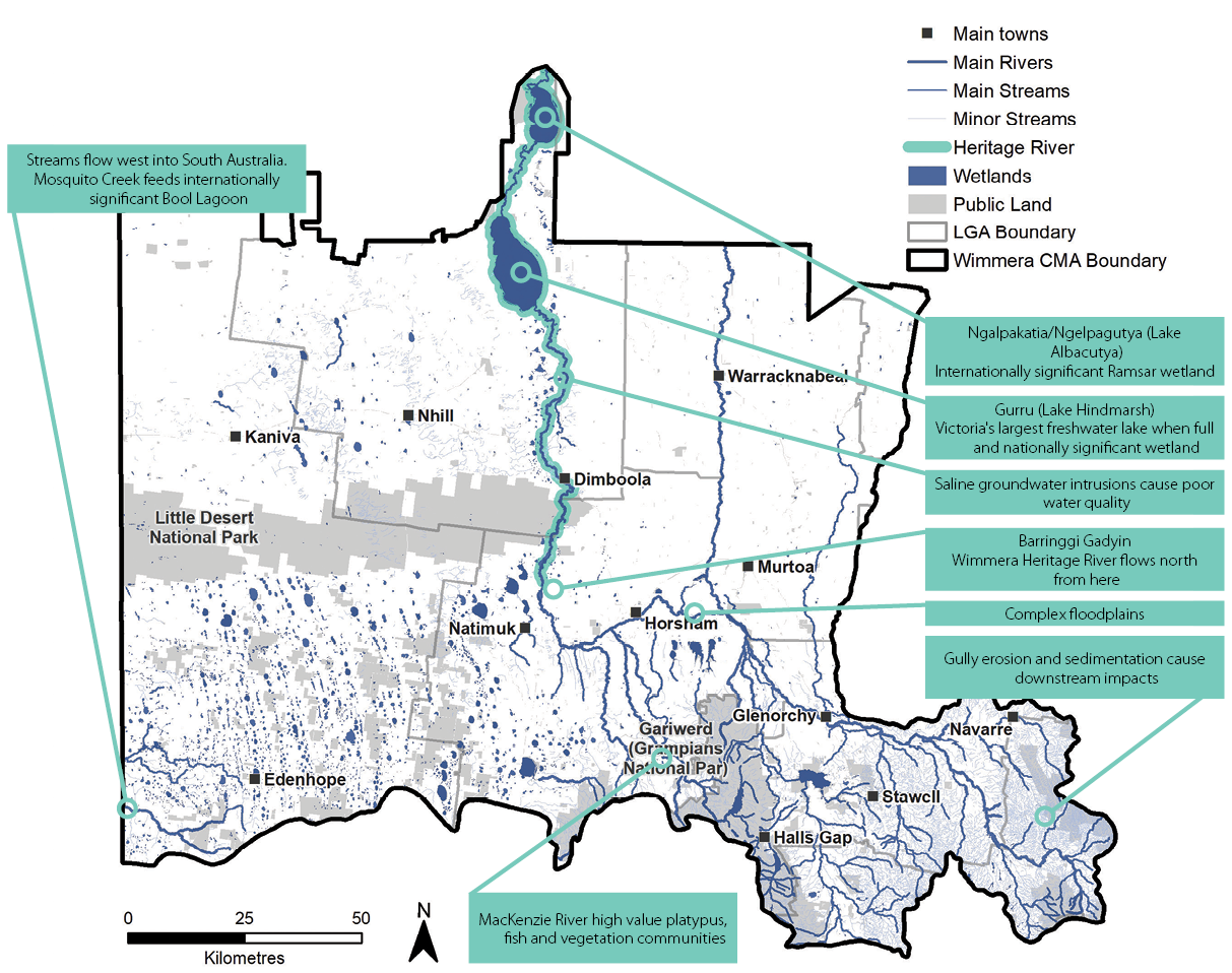
The Wimmera’s two river basins are the Wimmera-Avon Basin comprising most of the region’s east and the Millicent Coast Basin covering the western part of the region. The Wimmera basin comprises part of the Murray Darling Basin and extends north and east into the Mallee and North Central Catchment Management Authority (CMA) regions.
The major waterway in the Wimmera-Avon Basin is the Barringgi Gadyin (Wimmera River) which is the largest river in Victoria that cannot flow out to the sea.
Major rivers and streams in the Wimmera
It’s catchment has numerous tributaries arising in Mount Buangor State Park, the Pyrenees range, Gariwerd (Grampians National Park) and the Black Range Scenic Reserve near Stawell. The Barringgi Gadyin (Wimmera River) flows through Glenorchy, Horsham, Quantong, Dimboola and Jeparit before entering Gurru (Lake Hindmarsh).
During exceptionally wet periods, Gurru (Lake Hindmarsh) will fill and spill into Outlet Creek and onto Ngalpakatia/ Ngelpagutya (Lake Albacutya), an internationally significant Ramsar–listed wetland. The catchment extends beyond Ngalpakatia/Ngelpagutya (Lake Albacutya) into the Mallee CMA region with numerous smaller lakes before reaching the Wirrengren Plain. Historic records show occasional flooding of lakes beyond Ngalpakatia/Ngelpagutya (Lake Albacutya), though they have not received floodwater since the 1970s.
The Barringgi Gadyin (Wimmera River) between Polkemmet and the Wirrengren Plain has been proclaimed a Victorian Heritage River due to its significant environmental, cultural and social values (Heritage Rivers Act 1992).
A notable feature of the system is the distributaries, Dunmunkle and Yarriambiack Creeks, which carry water from the Barringgi Gadyin (Wimmera River) during high flows and floods. Yarriambiack Creek flows from Longerenong through Jung, Warracknabeal and Brim and onto Lake Coorong near Hopetoun in the Mallee. The Dunmunkle Creek is a highly modified stream that carries water north from Glenorchy through Rupanyup, dissipating in the southern Mallee.
The Wimmera Basin also contains a few stand-alone streams that flow into wetlands, for example Natimuk Creek feeds Natimuk Lake and Lake Wyn Wyn. The Millicent Coast Basin extends south into the Glenelg Hopkins CMA region and west into south-eastern South Australia. It is characterised by several streams that flow west. Mosquito Creek is an important stream as it flows from south- west of Edenhope through to the Bool and Hacks Lagoons Ramsar site near Naracoorte.
The Wimmera’s rivers and streams provide most of the water needed for towns and farms, especially via the Wimmera Mallee Pipeline. Many townships are located adjacent to rivers and streams for historic water supply, recreational and aesthetic purposes, so many have weirs to retain water levels through drier periods. Rivers and streams underpin local tourism and recreation. Camping, fishing, walking, canoeing, rowing, bird watching and swimming are popular activities that local residents enjoy. These attractions bring visitors to the region and significant tourism dollars.
The Wimmera’s rivers and streams also support significant local events such as fishing competitions, rowing regattas and festivals. A study into the socio-economic value of environmental water demonstrated that the Barringgi Gadyin (Wimmera River) alone generates around $4.75 million a year and has additional health benefits for the community worth $2.5 million annually.(6)
Rivers and streams support some irrigation of grape vines, pasture and annual crops. Water is also supplied to local industry, intensive agriculture and mining enterprises.
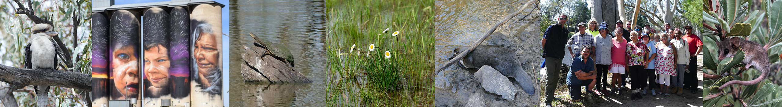
Rivers and streams form natural corridors in a largely agricultural landscape and a large variety of wildlife rely on them for habitat. Examples include freshwater catfish (Tandanus tandanus), river blackfish (Gadopsis marmoratus), western swamp crayfish (Gramastacus insolitus), rakali or water-rat (Hydromys chrysogaster) and platypus (Ornithorhynchus anatinus).
The corridors of native vegetation that parallel rivers (riparian corridors) provide vital habitat for a variety of bird life, vegetation and other species. For example, bird surveys have highlighted the importance of habitat adjacent to waterways with higher abundance and diversity of birds recorded. The north to south running corridors provided by the Wimmera River, Yarriambiack and Dunmunkle Creeks and some southern streams could play an important future role in facilitating the migration of species like nationally threatened regent parrots (Polytelis anthopeplus) and Major Mitchell’s Cockatoo (Lophochroa leadbeateri) to suitable southern habitats under hotter and drier climate change scenarios.
There is occasional flooding of towns across the Wimmera. Floods can severely disrupt communities by causing property damage, personal hardship, regional economic loss, injury and potentially loss of life.
Assessment of current condition and trends
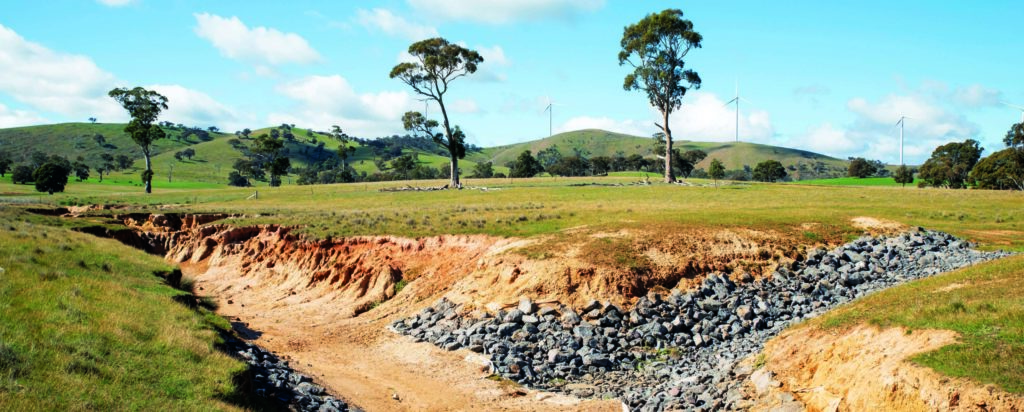
Erosion control works in the upper Wimmera catchment
The major rivers and streams in the region are ‘working rivers,’ particularly the lower reaches. Working rivers, while they have been significantly modified through weirs, water harvesting and mining, retain high environmental, economic, social and cultural values.
Significant efforts by the community, with the support of government, have protected reaches in good condition and enhanced reaches in farming land through riparian vegetation management and erosion control works. Between 2015-16 and 2019-20, Wimmera CMA and landholders have established 663 kilometres of fence to protect rivers and streams.
These efforts are steadily reversing the negative outcomes of the past including impacts of historic drainage works, stock access, vegetation removal, gold dredging, water harvesting, pest and weeds. This is leading to improved water quality, aquatic and riparian habitat.
Substantial water savings have resulted over the past decade from replacing the historic stock and domestic water supply open channel system with pipelines and the buyout of irrigation entitlements. This has improved water availability for regulated rivers and streams. The combination of these efforts is building greater resilience so that rivers and streams can cope with natural disturbances like drought, floods, bushfires and climate change.
The Wimmera Mallee Pipeline has improved the availability of water for environmental outcomes and delivered flow-on economic, social and cultural benefits. Habitat restoration and fish stocking is improving the health of native fish and fishing opportunities.
These integrated catchment management efforts are creating positive benefits for rivers and streams. For example, there have been no major blue green algae outbreaks in the Barringgi Gadyin (Wimmera River) since 2010 despite a series of very dry years.
The combination of environmental water availability, improved habitat and threat management has seen some water-dependant species expand their range in the MacKenzie River and Burnt Creek, including the platypus (Ornithorhynchus anatinus), western swamp crayfish (Gramastacus insolitus), southern pygmy perch (Nannoperca australis) and obscure galaxias (Galaxias oliros). The same has unfortunately not occurred in upper catchment streams.
There have been significant fish stocking programs in the Barringgi Gadyin (Wimmera River) by the Victorian Fisheries Authority. Around 430,000 fish were released between 2017 and 2020. This has complemented other integrated catchment management efforts, achieving significant benefits for recreational fishing. The number and size of native fish caught by anglers continues to increase. Conversely carp (Cyprinus carpio) numbers remain comparatively modest with limited breeding events and increased predation of juveniles.
Water for the environment has contributed to cultural outcomes for First Nations people. For example water has been used to support events on the Barringgi Gadyin (Wimmera River) such as the Goolum Goolum Wimmera River challenge and has been used to improve environmental values at the Ranch Billabong in Dimboola which is a significant cultural place.
There is still a lot of work to do to improve the health of rivers and streams. There are ongoing issues with water quality, lack of flow, erosion and depleted riparian vegetation in many parts of the catchment.
Unregulated reaches in the Upper Wimmera and Millicent Coast catchments are experiencing less flow due to climate and land use change and water harvesting, including from farm dams. In the Upper Catchment this has resulted in loss of river blackfish (Gadopsis marmoratus) and platypus (Ornithorhynchus anatinus) in recent years.
Despite improved entitlements for water for the environment, the lower reaches of the Barringgi Gadyin (Wimmera River) and other streams are still not assured adequate supply due to climate and land use change leading to reduced river flows. This means that parts of the system are susceptible to high salinity levels and decreased water quality in low rainfall years. This impacts on social and economic outcomes as well as aquatic habitat and wildlife.
Flood studies have been completed for most of the Wimmera’s high-risk waterways, providing a strong basis for regional floodplain management planning and reduced risk for lives and property. Many of these studies have been incorporated into planning schemes allowing for sound planning decisions. The introduction of the Wimmera Floodplain Management Strategy 2017 and the implementation of the associated work plan will continue to drive improvements such as enhanced flood flow monitoring and warnings.
Wartook Reservoir has a high demand for water supply relative to its size and average inflows. The reservoir supplies water for the Horsham and Natimuk townships, parts of the Wimmera Mallee Pipeline and water for the environment for the MacKenzie River and Burnt and Bungalally Creeks. This high demand affects the reliability of supply particularly in a drying climate. When the storage is low there are trade-offs in water supply. Without supplementary water supply, communities will need to reduce water consumption if environmental values are to be maintained. For example, platypus habitat will be lost without regular water flows in the MacKenzie River. |
Major threats and drivers of change
Flow regimes of rivers and streams are being impacted by climate change and drought. The Victorian Water and Climate Change Initiative’s research shows that rainfall has decreased significantly over the past 30 years in the upper catchment leading to reduced flows in rivers and streams.(7) This is magnified by harvesting of water from rivers and streams into dams and reservoirs for consumptive uses.
Land use changes such as transitioning from grazing to dryland cropping can also impact on flows where it captures and retains more water in the landscape. Lack of flows impacts on the community’s ability to use water in rivers and streams for recreation or use because of inadequate water levels and poor water quality. More storms in summer have the potential to generate flows that may result in blackwater events. There are also impacts to aquatic life including fish and native vegetation. Drought refuges play an ongoing important role in supporting habitat for aquatic life during droughts so they can flourish when water returns.
Accelerated erosion of the bed and banks of rivers and streams can occur due to lack of adequate vegetation. Sediment and nutrients are entering rivers and streams because of runoff from land with inadequate ground cover, particularly in the Upper Catchment where bare soils are particularly prone to erosion. This movement of sediment can also cause infilling and smothering of waterholes downstream, reducing deep pool habitat and drought refuge pool capacity.
Salinity and rising water tables are intersecting with rivers and streams and can cause pollution of waterholes leading to fish deaths and loss of habitat for aquatic flora and fauna. In 2020 salinity levels in the Barringgi Gadyin (Wimmera River) downstream of Dimboola at Tarranyurk reached over 40,000 μS/cm after 5 months without flow. In comparison, sea water is around 54,000 μS/cm and water in the Wimmera’s water supply systems for stock and domestic supply is around 500 μS/cm.
Carp continue to live and breed in many rivers and streams, causing turbidity and competing with native fish species.
Riparian vegetation provides vital habitat for many of native species. It can also be impacted by firewood harvesting and inappropriate recreation pressures, potentially impacting on habitat and cultural heritage.
Many natural processes that support aquatic life have been impacted because of instream infrastructure. For example, fish movement is hampered by weirs. In some cases, there is a lack of instream habitat for aquatic wildlife. This can also devalue fish stocking programs.
Many of the region’s rivers and streams are not accessible to the community, meaning they cannot be used for recreation or cultural activities. This limits the community’s ability to derive social, economic and cultural benefits. Many have inappropriate infrastructure to support sustainable access. The use of these areas needs to be carefully managed to ensure environmental values are not impacted.
Desired outcomes for the future
Outcomes to be achieved in 20+ years
- The knowledge and experience of First Nations people is informing water planning, management and delivery in the Wimmera.
- The Wimmera Heritage River’s values are maintained or improved.
- The connectivity and condition of native vegetation along riparian corridors are improved.
- Water quality is improved at important areas for water supply, environmental and recreational values.
- Rivers and streams with high environmental, social, cultural and economic values are improving their value despite climate change.
Outcomes to be achieved in 6 years
- Ongoing collaboration and two way learning in river and stream planning and management by supporting and strengthening partnerships with First Nations people.
- Recreational participation numbers on the Barringgi Gadyin (Wimmera River) are increasing.
- More river and stream reaches have improved management of and access for recreation.
- Healthier rivers and streams enable more on Country activities for First Nations people.
- Blue green algal blooms and fish deaths are prevented where possible in the Barringgi Gadyin (Wimmera River).
- No new pest plants and animals are established beyond small, localised populations.
- More rivers and stream reaches have less stock access.
- More reaches have improved riparian width and connectivity.
- More river reaches are permanently protected through management agreements.
- Drought refuges are protected and retain water during drought.
- Net rates of streamflow interception are stabilising.
- Native fish and platypus are increasing their abundance and distribution.
- Native fish numbers are greater than carp numbers in most fish surveys and fishing competitions.
Complementary Plans
Wimmera Waterway Strategy
The Wimmera Waterway Strategy 2014-22 is an action plan for the Regional Catchment Strategy (RCS) that details the actions required to achieve the long-term and short-term outcomes for Rivers and Streams. It identifies priority waterways and includes a detailed set of management targets for each priority. It will be reviewed to align with the RCS once the RCS is approved.
Wimmera Floodplain Management Strategy
The Wimmera Floodplain Management Strategy outlines priority actions designed to deliver floodplain specific outcomes outlined in the RCS.
Wimmera Strategic Directions Statement
The Wimmera Strategic Directions Statement outlines the priority integrated water management projects for the region. They are designed to improve the liveability of the region’s towns and city by implementing improvements to the regional water cycle. It supports and complements the outcomes in the RCS.
Environmental Water Management Plans
The Environmental Water Management Plan for the Wimmera River System establishes environmental objectives for the Wimmera River, its regulated tributaries (lower Mt William Creek, MacKenzie River, Burnt Creek and Bungalally Creek) and Yarriambiack Creek. The plan sets out the environmental water requirements to attain the environmental objectives over a multi-year watering regime (assuming sufficient environmental water is available).