Our vision for the region is for a healthy Wimmera catchment where a resilient landscape supports a sustainable and profitable community. | |||
Water, land and biodiversity
The Wimmera region covers approximately 10% of Victoria and is the fifth largest catchment management region in Victoria, encompassing 2.3 million hectares.
The landscape is dominated by broadacre cropping, covering 1.2 million hectares or 53% of the region. The gross value of agricultural production in the Wimmera in 2015-16 was $691 million. Farm cash income was $378,000 in 2019-20 compared to $184,000 in 2018-19. Median property size is 765 hectares and increasing.(2)
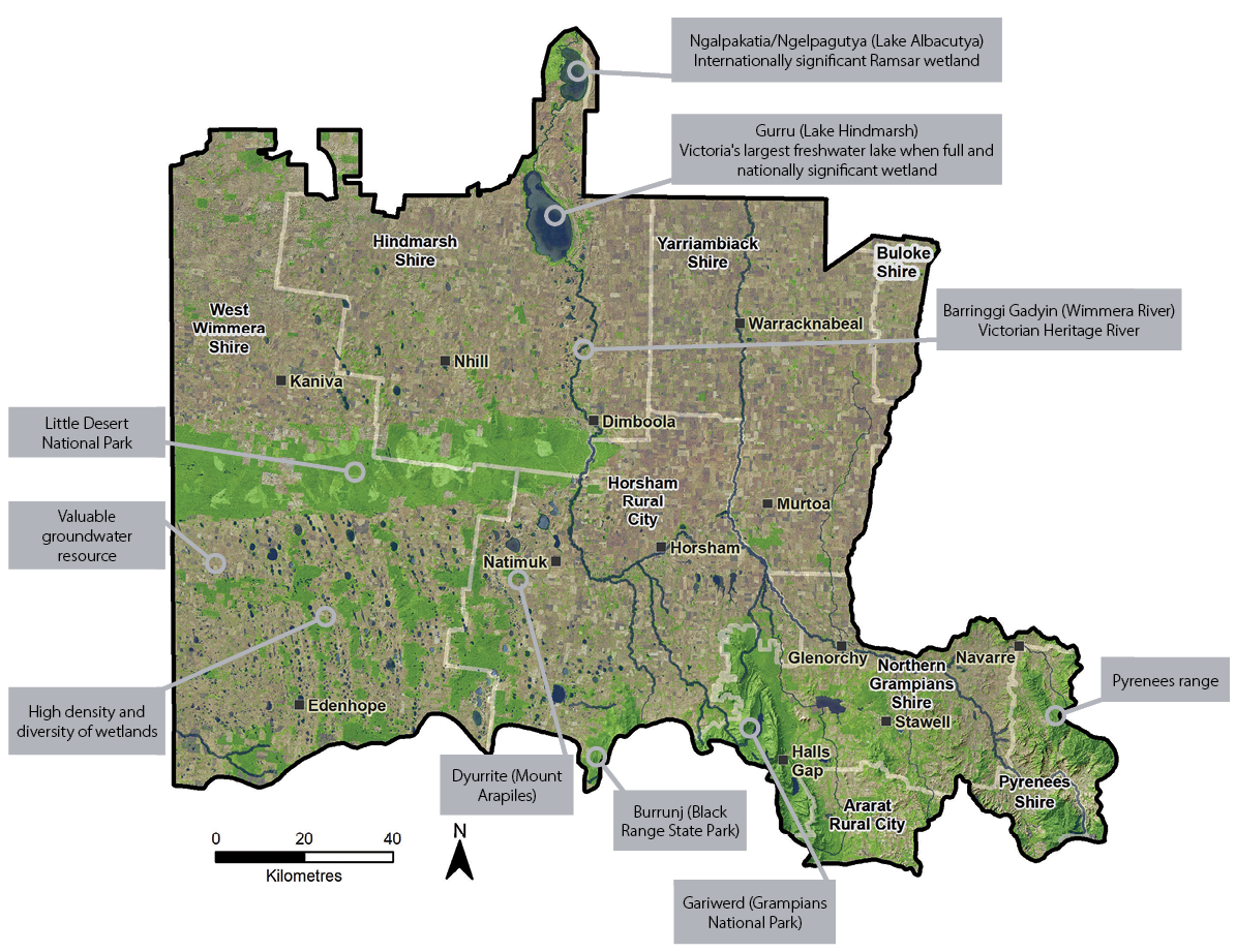
Figure 2: The Wimmera region
The Wimmera’s waterways are oases in a relatively dry landscape. Major catchments include the Wimmera Basin and the eastern part of the Millicent Coast Basin. The Barringgi Gadyin (Wimmera River) is the largest Victorian river that does not flow to the sea, instead flowing to Victoria’s largest freshwater wetland, Gurru (Lake Hindmarsh), then into Ramsar listed Ngalpakatia/Ngelpagutya (Lake Albacutya) and beyond. Ramsar refers to the Convention of Wetlands of International Importance.
The Wimmera contains 25% of Victoria’s wetlands which are predominantly in the south west of the region. This area also contains a valuable groundwater resource, supporting a significant irrigation and grazing industry.
The Pyrenees Range, Gariwerd (Grampians National Park), Burrunj (Black Range State Park) and Dyurrite (Mt Arapiles) are predominant in the landscape. These reserves, along with the Little Desert National Park, are the largest in the region and are significant areas for biodiversity and recreation. Along with the many small and medium bush and wetland reserves scattered throughout the region, they support regional liveability, health and wellbeing, and environmental, socio- economic and cultural values. Gariwerd (Grampians National Park) alone attracts approximately one million people per year and is the second most popular national park in Victoria
People
The Wimmera’s population is approximately 50,000 with around one third of residents living on farms or in small townships with less than 2,000 people.
First Nations people are represented by Barengi Gadjin Land Council Aboriginal Corporation (BGLC) and Eastern Maar Aboriginal Corporation. There is a deep and continuing connection between First Nations people and Country with many significant features linking directly to creation stories.
Health and wellbeing are influenced by a range of catchment management factors including the health of the local environment, access to recreational opportunities and connection with the community. The overall health status for the Wimmera community is poorer than the state average in many indicators. This is more pronounced in children and young people.
Wimmera Primary Care Partnership’s 2020 population health and wellbeing profile recognises there is a positive relationship between visits to green space and a range of health benefits. Residents of the Wimmera visited green space less than the state average. Despite this, residents in the Wimmera are more likely to attend community events and the meetings or social events of local clubs and groups than the state average.(3) Regional Landcare leaders have reported that volunteer numbers are generally steady overall but patchy and fluctuating at a local level. Some groups have increased volunteers while others have decreased indicating that the trends for Landcare may be different to other activities.
Sixty-three per cent of farmers work full-time on farm hours, and they manage 90% of the agricultural land. Approximately 32% of landholders are members of Landcare while 28% are members of agricultural commodity groups.(4)
Local Areas
The five Local Areas in the Wimmera Regional Catchment Strategy focus on distinct parts of the region and explain how the themes come together and integrate in each place. The Local Areas are based around local government and catchment boundaries. This recognises the importance of local community ownership, participation and management and demonstrates integrated catchment management.
The Local Areas in this strategy are:
- Hindmarsh
- Horsham
- West Wimmera
- Yarriambiack and Buloke
- Upper Catchment (including parts of Ararat, Northern Grampians and Pyrenees local government areas).
Opportunities and challenges
Liveability
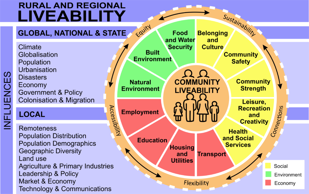
Integrated Catchment Management (ICM) plays an important role in improving the liveability of the region. ICM supports healthy functioning ecosystems and biodiversity.
This contributes to a range of liveability benefits, including clean water, healthy food, cooler towns, visual amenity and encouraging active living. Community participation in ICM creates social inclusion and empowerment.
ICM provides multiple outcomes beyond direct environmental outcomes. ICM practitioners working in collaboration with primary care service providers, local planners and the community can maximise liveability outcomes.
Figure 3 shows a range of influences affecting rural and regional community liveability.
Climate change
Climate change will continue to shape the region. Many predicted consequences under various greenhouse gas emission scenarios have already been experienced. For example, the Bureau of Meteorology and Commonwealth Scientific and Industrial Research Organisation have observed that in the Wimmera in the last 30 years:
- Annual rainfall has decreased by 9%.
- Dry years have occurred 12 times and wet years have occurred five times.
- Rainfall has decreased in the autumn and spring months.
- The autumn break is one to three weeks later (typically occurred in early to mid-May south of Horsham, and in late May to early June in the central and northern part of the region).
- More frosts have occurred and they are occurring later in growing season.
- There were more consecutive days above 40°C. (5)
Truth telling commission
Prior to colonisation the Wimmera landscape was healthy and provided sustenance for the people and wildlife that lived here. With European settlement came foreign plants and animals and changed management practices which impacted the land and the people. First Nations people were forced out of the landscape and could not maintain their obligations to Country. The First Peoples Assembly of Victoria and the Victorian Government have made a shared commitment to truth telling through the Yoo-rrook Justice Commission. The Commission is expected to establish an official record of the impact of colonisation on First Peoples in Victoria and make recommendations about practical actions and reforms needed. This will guide integrated catchment management actions in the Wimmera into the future.
Landholder identified issues
As most land in the region is privately owned and managed it is vital to support landholders so they can continue to contribute to improving the environment for the benefit of the whole community.
A survey of rural landholders found that the top three property related issues for landholders are:
- Impact of drought and/or changing rainfall patterns on property viability: 79%
- The impact of weeds and pest animals (including native species) on profitability: 66%
- Impact of poor management of pest plants and animals on public land: 61%
The top three district issues for landholders are:
- Impact of reduced water flows on the long-term health of rivers/streams/wetlands: 63%
- Reduced opportunities for recreation as lakes dry out: 61%
- Decline in soil health: 59%(4)
New technology and innovation
New technology and innovation are significant factors for managing challenges, maximising opportunities and improving the wellbeing and liveability of the region. New technology and innovation can change management practices, increase uptake of more sustainable and profitable farming and provide solutions to many ICM challenges.
Mining
The Wimmera’s mining history has largely been focused on gold mining in the Upper Catchment which stretches back to 1850s. More recently the Wimmera has been recognised as a world priority area for mineral sands mining with several significant ventures in the early stages of development. It will be important to ensure that any mining development appropriately meets environmental, social and governance expectations. Specific consideration should be given to agricultural food production, tourism, public amenity and water availability.
Illegal waste dumping
The illegal dumping of waste can impact on waterways and groundwater, contaminate soils and impact on wildlife and human health. Relevant agencies and the community need to be vigilant in observing, reporting and responding to illegal waste dumping.