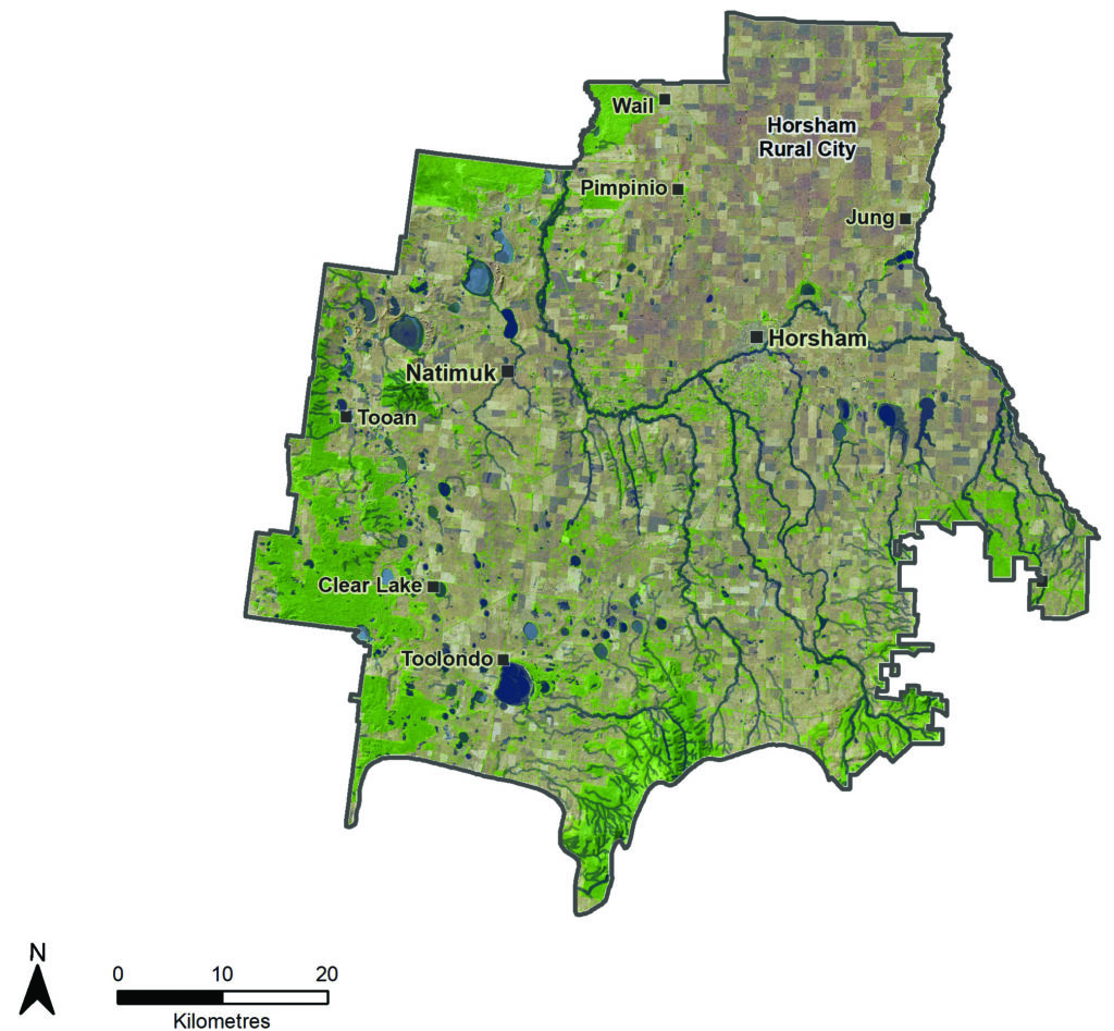
The Horsham Local Area has the largest population of any municipality in the Wimmera, most of which reside in the Horsham township. | |||
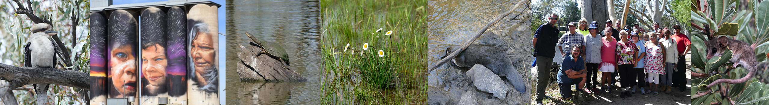
First Nations communities retain a strong connection between the land and water. The creation story of the Barringgi Gadyin (Wimmera River) continues to be told and there are significant sites associated with the Barringgi Gadyin (Wimmera River) in Horsham. In Dyurrite (Mount Arapiles) there are examples of local rock art, nationally significant stone tool making site and quarry sites. There are many scar trees and artefact scatters associated with woodland communities.
There are strong industry and community support networks aimed at improving natural resource management outcomes for the region. Examples include:
- Agriculture groups with members in the area, for example Victorian No-Till Farmers Association, Birchip Cropping Group, Wimmera Farming Network
- Landcare groups
- Friends of Groups, for example Wimmera River Improvement Committee
- Committees of management for example Natimuk Lake Foreshore Committee
This is a largely agricultural landscape with dryland cropping making up 60% of the area.(25) As a result grain production is the main economic industry. There is also a significant grazing industry where stock are incorporated into grazing systems. Dedicated pastures are more prevalent in the south. There are also niche agricultural industries like olives and cut native flowers.
The area has many important waterways. The MacKenzie River supports a small population of platypus (Ornithorhynchus anatinus), while Burnt Creek supports the threatened western swamp crayfish (Gramastacus insolitus) and the most southern known population of the Peron’s Tree Frog (Litoria peronii). The Barringgi Gadyin (Wimmera River) is fringed by riparian vegetation which meanders through an agricultural landscape and provides a significant social, economic, cultural and environmental asset to the region. The Barringgi Gadyin (Wimmera River) weir pool in Horsham is a magnet for recreation and has attracted on average 81,000 participants per year between 2016 and 2020. Events like the annual Horsham fishing competition are a major drawcard. In 2019-20 visitors spent around $843,927 in the local economy.(6)
The Horsham Local Area contains 531 functioning wetlands, including 177 shallow freshwater marshes and 154 freshwater meadows. In the south and west there are diverse and a high density of wetlands. Most are on private land. Many provide significant habitat and recreational opportunities. The Natimuk-Douglas chain of lakes is a unique chain of salt and freshwater wetlands that are important for migratory birds.
The local community and visitors enjoy the many waterways throughout the Horsham Local Area. There is a desire to improve sustainable access to waterways to improve the local economy and health outcomes.
There is a small but valuable groundwater resource to the north of Gariwerd (Grampians National Park) that is only used in extreme drought to augment Horsham’s water supply.
A range of endangered plants and animal communities live here. Pine-Buloke Woodlands exist west of Gariwerd (Grampians National Park). There are remnant Salt Paperbark communities on the edges of some salt lakes and in some of these the rare Bead Glasswort (Halosarcia flabelliformis) can be found. Small patches of Grey-box woodlands are scattered throughout. Platypus (Ornithorhynchus anatinus) are in the upper MacKenzie River and are an iconic species that is under threat. Examples of endangered species include striped legless lizard (Delma impar), bush stone-curlew (Burhinus grallarius), brolga (Grus rubicunda), Grampian’s duck orchid (Paracaleana disjuncta), and Wimmera bottlebrush (Callistemon wimmerensis).
Significant areas are managed in reserves for example the Dyurrite (Mount Arapiles) and Tooan State Park and the Burrunj (Black Range State Park).
Region quick stats
 |
Land area | 377,913 hectares |
 |
Population | 19,600 (approximate)(68) |
 |
Population trend | Growing. Expected to be 21,794 by 2031(74) |
 |
Main towns | Horsham, Natimuk, Jung, Pimpinio, Laharum, Wail, Dadswells Bridge, Toolondo |
 |
Climate |
Semi-arid. Summer temperatures can reach over 40 degrees and regular frosts are experienced in winter. Average annual rainfall is around 450 mm. |
 |
Land use | 70% of the area is dryland broadacre cropping(25) |
 |
Main industries |
Agriculture: cropping, wool and sheep meat, major producer and exporter of hay. Agricultural manufacturing: grain handling businesses, silo and grain handling equipment. Health services. Tourism. |
 |
Main natural features |
27% of the area is covered by native vegetation and waterways(25)
|
Assessment of current condition and trends
 Rivers and streams
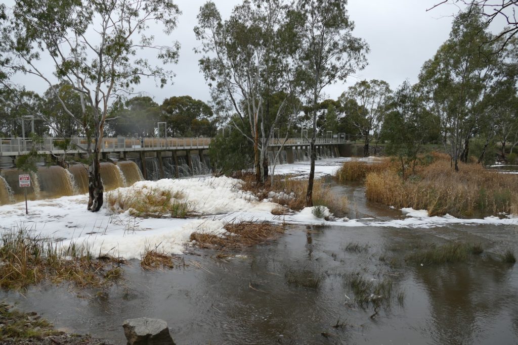
Wimmera River, Horsham weir
There has been a concerted effort to improve runoff water quality into the Barringgi Gadyin (Wimmera River) in Horsham over the past 10 years, with more to do. Most of the Barringgi Gadyin (Wimmera River)’s water quality issues stem from erosion in the upper catchment. The Barringgi Gadyin (Wimmera River) at Horsham regularly fails to meet water quality targets in the State Environment Protection Policy for phosphorus, nitrogen, turbidity and pH. Despite this the water quality in Horsham’s weir pool has been good enough to prevent algal blooms and allow for recreation. This has been assisted by water for the environment. In 2019 platypus surveys showed that environmental flows were helping improve the distribution of platypus in the MacKenzie River.
Socio-economic research has shown that participation at the Horsham weir for recreation has increased from 78,300 participants in 2016-17 to over 84,000 in 2018-19 and 2019-20. This is likely to be attributed to the additional walking tracks and boating facilities that have been installed and emergence of new activities such as the Horsham Park Run which uses the new walking tracks.
Annual surveys and Horsham Fishing Competition results have indicated that European carp (Cyprinus carpio) numbers in the Barringgi Gadyin (Wimmera River) reduced and then stabilised (Figure 14). This is likely to be because of healthy native fish populations due to fish stocking, environmental water delivery, carp removal programs and water quality efforts.
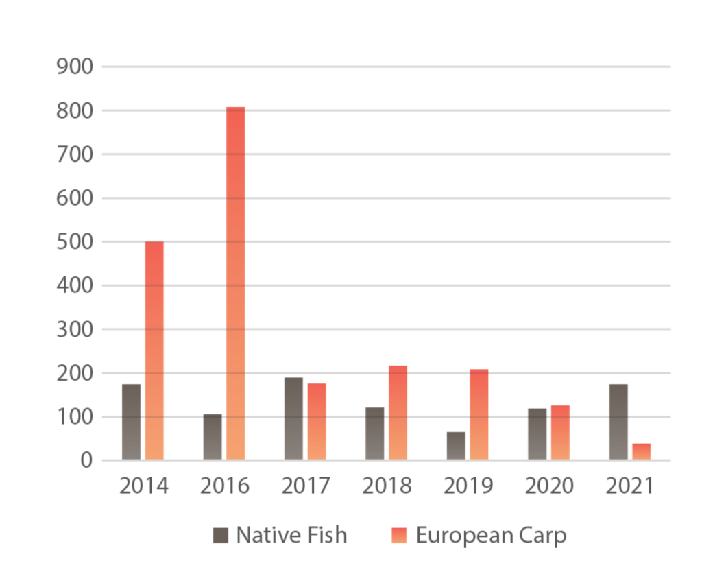
Figure 14: Horsham fishing competition total catch from 2014 to 2020(75)
Wetlands
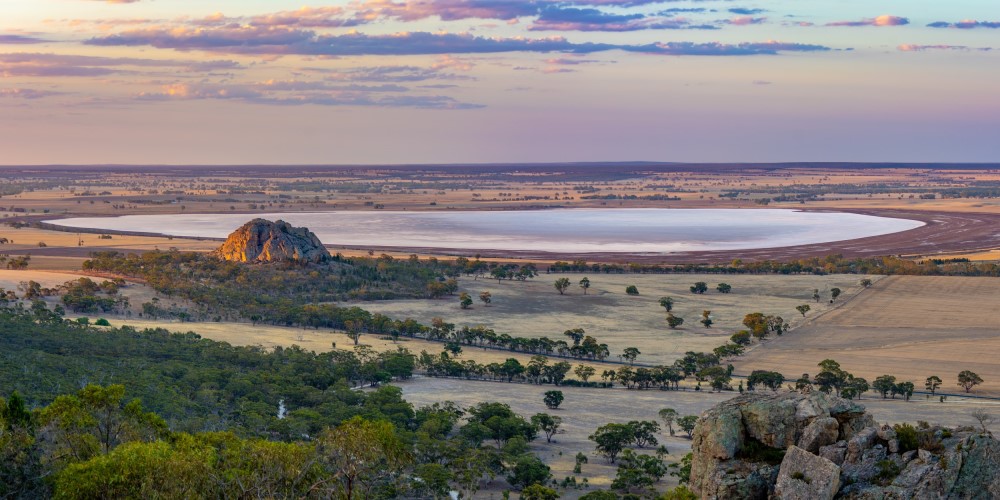
Mitre Rock and Mitre Lake
Of the 538 wetlands located in the Horsham Rural City, 170 are free from modifications such as dams, drains, cropping or levees. In 2017, 140 wetlands were cropped compared to 75 in 2004 indicating there is a continued impact on wetlands.
Many wetlands do not contain water for as long as they once did. For example, Lake Natimuk has been shown to be at risk of a changed hydrologic regime due to climate change and improved agricultural practices to retain soil moisture.(15)
The recreational use of some of the Local Area’s significant water bodies is influenced by several factors. Green Lake is frequently impacted by blue-green algae. When it has been clear of algal blooms its value increases. For example, in 2016-17 over 10,000 participants used Green Lake compared to 2018-19 and 2019-20 when the participation was 2,000 and 1,700 as a result of algae outbreaks. Taylors Lake continues to maintain a healthy participation rate as its volume is maintained at a level that is suitable for recreation and its water quality is relatively good. Toolondo Reservoir’s participation rates are dependent on water levels. Since 2017-18 participation rates have dropped from 3,340 to 358 in 2019-20 due to declines in water levels and quality.
 Land
Land
Australian Bureau of Statistics data reveals that the gross value of agricultural commodities in the Horsham Local Area in 2015-16 was $160.9 million of which $99.99 million was from cropping.(2) This compares with $217 million and $161 million in 2010-11 respectively.(2) Variations are likely to be due to seasonal conditions effecting yield and commodity prices.
With the introduction of no-till and minimum till cropping practices the area susceptible to wind erosion has declined from times when conventional farming practices prevailed. Cropping transect surveys in autumn indicate that the percentage of land vulnerable to erosion fluctuates. For example, in 2016 there was 100% ground cover recorded while in 2018 there was 88.3% cover.
Victorian Land Cover Time Series mapping indicates that between 2005-10 and 2015-19 dry land cropping increased in the area by around 16,000 hectares. This mirrors 18,000 hectares of native grassland loss. This is likely to be because of cropping expanding to the south.(25)
 Biodiversity
The Victorian Land Cover Time Series also indicates that the area of native trees has remained at around 50,000 hectares between 2005 and 2019 indicating that revegetation efforts are keeping up with clearing.
There have been observations of paddock trees being lost but the extent has not been determined.
After significant contractions during the Millennium Drought the platypus’s range has gradually extended down the MacKenzie River. Surveys and environmental DNA sampling have found that the entire reach from Dad and Dave Weir to Distribution Heads is now colonised. Although the population distribution has expanded, the genetic diversity and viability remains low.(76)
There have been several incentives programs conducted where landholders have been funded to protect and manage buloke (Allocasurina luehmannii) and grey box (Eucalyptus macrocarpa) woodlands. There have also been numerous weed and pest control activities aimed at reducing threats to native plants and animals.
Major threats and drivers of change
Climate change is a significant impact on the Horsham Local Area. Climate change is impacting on water availability to waterways including the Barringgi Gadyin (Wimmera River), MacKenzie River, Burnt Creek, Mount William Creek, Bungallally Creek and its many wetlands for example Natimuk Lake and Lake Toolondo. This can impact on water quality and cause impacts to recreational environmental values. In rivers and streams it can impact on native animals. For example the Burnt Creek once had river blackfish (Gadopsis marmoratus) down its entire length.
The impact of climate change is magnified by the high demands on Wartook Reservoir for water supply for Horsham and the environment. This means that during dry times authorities’ ability to supply water can be compromised meaning social, economic and environmental outcomes are traded off. For example, platypus and river blackfish cannot extend their range to the Barringgi Gadyin (Wimmera River) and Horsham’s residents and businesses are impacted by water restrictions.
Currently Horsham’s region is reliant on agriculture for its economic prosperity. Climate change puts this at risk and farmers are continuing to adapt their businesses as they continue to invest in techniques and technology that focus on soil moisture retention because of reduced rainfall.
Land use change can impact on the value of natural assets. Cropping or modification of wetlands can reduce their ability to provide recreational opportunities or environmental value.
This is a particular issue in the Horsham Local Area as the majority (177) are shallow freshwater wetlands that often dry out. Converting land from grazing to cropping can impact on the health and persistence of paddock trees. This needs to be factored in when making decisions about water availability.
The community has a strong desire to access public areas in the municipality for recreation, in particular waterways. This access contributes to improved liveability by improving opportunities for active living but also provides opportunities to improve the economy through tourism and recreation. This access needs to be managed so it is safe and does not impact on the biodiversity, water quality and amenity of these sites. This has been a focus area for Wimmera Catchment Management Authority (CMA), Horsham Rural City Council and community groups over the past four years.
In some areas south of Horsham inappropriate fire management of stubble burning has occurred causing the destruction of paddock trees. Stubble burning can also remove ground cover, increasing the risk of wind erosion of topsoil. Fire needs to be understood and managed to ensure the farm profitability and conservation outcomes are both possible.
Horsham’s rivers and wetlands provide essential corridors for wildlife and can also be vectors for invasive plants and animals. These areas require ongoing management by land managers to ensure they continue to maintain their values.
Erosion and sediment movement in waterways in the Upper Wimmera catchment can impact on the water quality in the Barringgi Gadyin (Wimmera River) particularly in the Horsham weir pool. Slowing water movement and improving ground cover on the banks of the river can reduce turbidity of waterways.
Desired outcomes for the future
Outcomes to be achieved in 20+ years
- The community’s health and wellbeing has improved.
- The Barringgi Gadyin (Wimmera River) is maintained in a state that continues to support social, environmental, cultural and economic values.
- The Natimuk-Douglas Chain of lakes values retain their national significance.
- MacKenzie River, Burnt and Bungalally Creeks run more often to the Barringgi Gadyin (Wimmera River).
- Platypus and river blackfish extend their range.
- Native vegetation extent and connectivity has increased.
- More wetlands are under improved management.
- Soils support productive agriculture and healthy, functioning natural environments.
Outcomes to be achieved in 6 years
- Waterway user participation numbers are maintained or improved on average in the Barringgi Gadyin (Wimmera River).
- More areas have improved recreational access and management.
- More water security by developing and implementing a business case for a supplementary water supply for Horsham and MacKenzie River, Burnt and Bungalally Creeks.
- More areas are permanently protected for biodiversity with a priority given to Shallow Seasonal Wetlands, grasslands and Woodlands.
- Increased weed, herbivore and pest predator control in priority locations.
- More revegetation in priority locations.
- Stubble is retained in at least 80% of cropping paddocks over summer.
- Land managers adapt practices and technologies to a changing climate.
- Increase land manager knowledge of management practices that contribute to healthy productive soils.
Priority directions
Integrated Catchment Management (ICM) in the northern portion of the Horsham Local Area including the Barringgi Gadyin (Wimmera River) will focus on:
- Community groups, Barengi Gadjin Land Council (BGLC), Horsham Rural City Council and government agencies working together to improve the opportunities the Barringgi Gadyin (Wimmera River) provides to the community. This will include a combination of environmental improvements and improved management of recreation, access and impacts.
- Farmers, Landcare groups, BGLC, government agencies and stakeholder organisations working together to build corridors of well-managed vegetation between private and public land particularly along the Barringgi Gadyin (Wimmera River).
- Farming groups, farmers and BGLC working together to improve techniques that balance ground cover, farm profitability and improved environmental outcomes.
Integrated catchment management in the southern portion of the Horsham Local Area including the MacKenzie River and wetlands will focus on:
- Farmers, Landcare groups, BGLC, government agencies and stakeholder organisations working together to build corridors of well-managed vegetation between private and public land particularly the MacKenzie River, Burnt Creek, the Barringgi Gadyin (Wimmera River) and wetlands.
- Farming groups, farmers and BGLC working together to improve techniques that balance ground cover, farm profitability and improved environmental outcomes.