| |||||

This section focuses on land use and management and how it underpins soil health.
Almost 80% of the Wimmera’s landscape supports a large agricultural industry which significantly contributes to the region’s economy and food security at a global and national scale.(21) Grain production is the Wimmera and southern Mallee’s biggest industry, providing 26% of Victoria’s grains, being cereals, legumes and oilseeds. This is followed by 16% of Victorian sheep meat production and 17% of Victoria’s wool production.(22) Viticulture, olives and native flowers are also significant primary industries in the region. The Pyrenees region, divided between the North Central and Wimmera regions, supports a significant wine industry, producing $56 million in outputs and a value add of $11.5 million.(23) The remaining 20% of land comprises national parks, crown land and urban areas. Figure 10 shows the coverage of different land use cover classes in the Wimmera.
Healthy soils have the physical, chemical and biological processes working together to support productivity, maintain environmental quality and promote plant and animal health.(24)
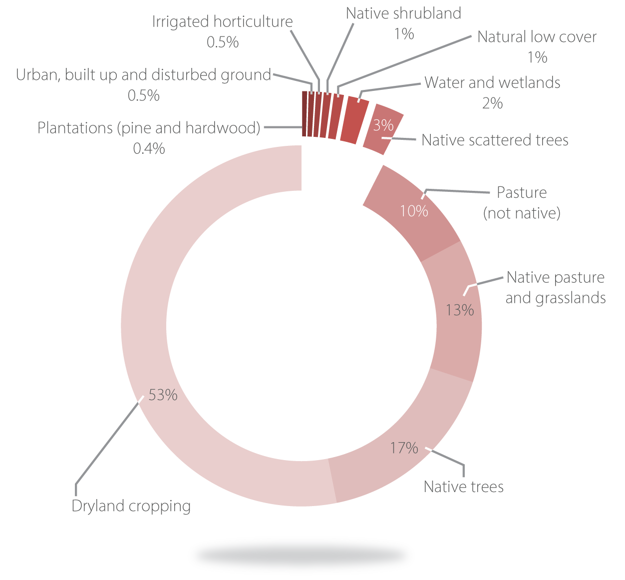
Figure 10: Percentage of land use cover classes in the Wimmera for the period 2015-2019(25)
The management of soils influences the health of natural assets, such as native vegetation and waterways by providing a healthy foundation for plants and animals and acting as a buffer to prevent sediments entering waterways.
Informed land management decision-making is critically important for sustaining this finite, fragile and complex resource into the future.
First Nations people’s connection to country is formed through a deep understanding and appreciation of the landscape. This provides a rich source of knowledge that can improve land and soil management policies and practices.
Wimmera soils have evolved over millions of years and can be grouped into four areas with common soil types and distinct landscape characteristics (Figure 11):
- Upper catchment
- Steep hillsides and valleys are covered (60% of the area) by alluvial and volcanic clays and texture contrast soils where sandy and loamy surface soils overlay heavy clay subsoils.
- Supports a mixture of livestock and cropping.
- Supports Gariwerd (Grampians) and Burrunj (Black Range), many public reserves and important waterways.
- North eastern plains
- Characterised by hummocky dunes, flat plains, rises and lake lunettes. About 75% of the area is comprised of cracking and self-mulching clays that shrink and swell with changing moisture content.
- Supports the largest area of cropping in the Wimmera plus important waterways.
- North western plains
- Regular, parallel dunes or ridges alternate with swales or depressions. Scattered lakes and lunettes are also present. Ninety per cent of the area is covered by sodic clays in the swales and siliceous dunefield sands.
- Supports predominately cropping plus the Little Desert and scattered reserves and wetlands.
- South west Wimmera
- Predominantly ridge and swale systems. Eighty- seven per cent of the area is covered by sodic clays and texture contrast soils.
- Supports a mixture of livestock and cropping plus a high density of wetlands and native vegetation.
Figure 11: Regional soil types and localised threats
Assessment of current condition and trends
Wimmera farmers have been adapting farm management practices in response to climate change. In the 30 years from 1989 to 2018, the Wimmera has experienced a 9% decrease in annual rainfall, more frosts occurring later in the growing season and more hot days (>38°C).(5) In response, farmers are using new technologies such as soil moisture probes, precision agriculture, minimum tillage and stubble retention to better inform land management practices that boost productivity and conserve soil and soil moisture.
Social research indicates that over 50% of Wimmera farmers are well-versed in management practices such as grazing and cropping strategies to manage ground cover and minimise soil erosion. Close to 50% of farmers reported sound knowledge in the use of stock containment areas, and the benefits of retaining native vegetation on properties.(4) This is substantiated by the 2019 Wimmera Land Use and Land Management Transect Surveys, where 15% of paddocks were recorded with exposed soil vulnerable to erosion, compared to 38% of paddocks in 1996.(26) This is a positive trend that requires continued support to ensure it is maintained.
Social research has also indicated that farmers are concerned about the impact of drought and changing rainfall patterns on property viability.(4) Climate modelling predicts that the Wimmera will continue to experience a reduction in rainfall, as well as an increase in the number of hot days.(27) These climate predictions present both challenges and opportunities.
Reduced growing season rainfall and rising temperatures will likely make agricultural productivity and profitability challenging. Management of soils must involve innovative strategies to improve soil health and resilience to climatic change. This challenge can be met by farmers, industry partners and researchers working together.
There is general understanding and continued practice of maintaining ground cover to reduce wind and water erosion amongst farmers.(2) This enables the retention and enhancement of healthy, productive soils and increases the amount of water available to plants to produce crops and pastures. These principles also apply to public land.
Established minimum tillage and stubble retention practices, maintenance of perennial pastures and ground cover, combined with climatic changes has likely led to a reduction in soil disturbance and erosion (Figure 12). The annual Wimmera Land Management and Land Use Transect Survey reports have tracked changes in land management trends since 1996. Over this time a 30% increase in the number of paddocks retaining stubble has been recorded in the northern Wimmera. There has also been a dramatic decline in large erosion events such as the 1983 dust storm that engulfed Melbourne. Such events cause highly valuable topsoil from the Wimmera and Mallee to be lost, which takes decades, if not centuries to renew.(28)
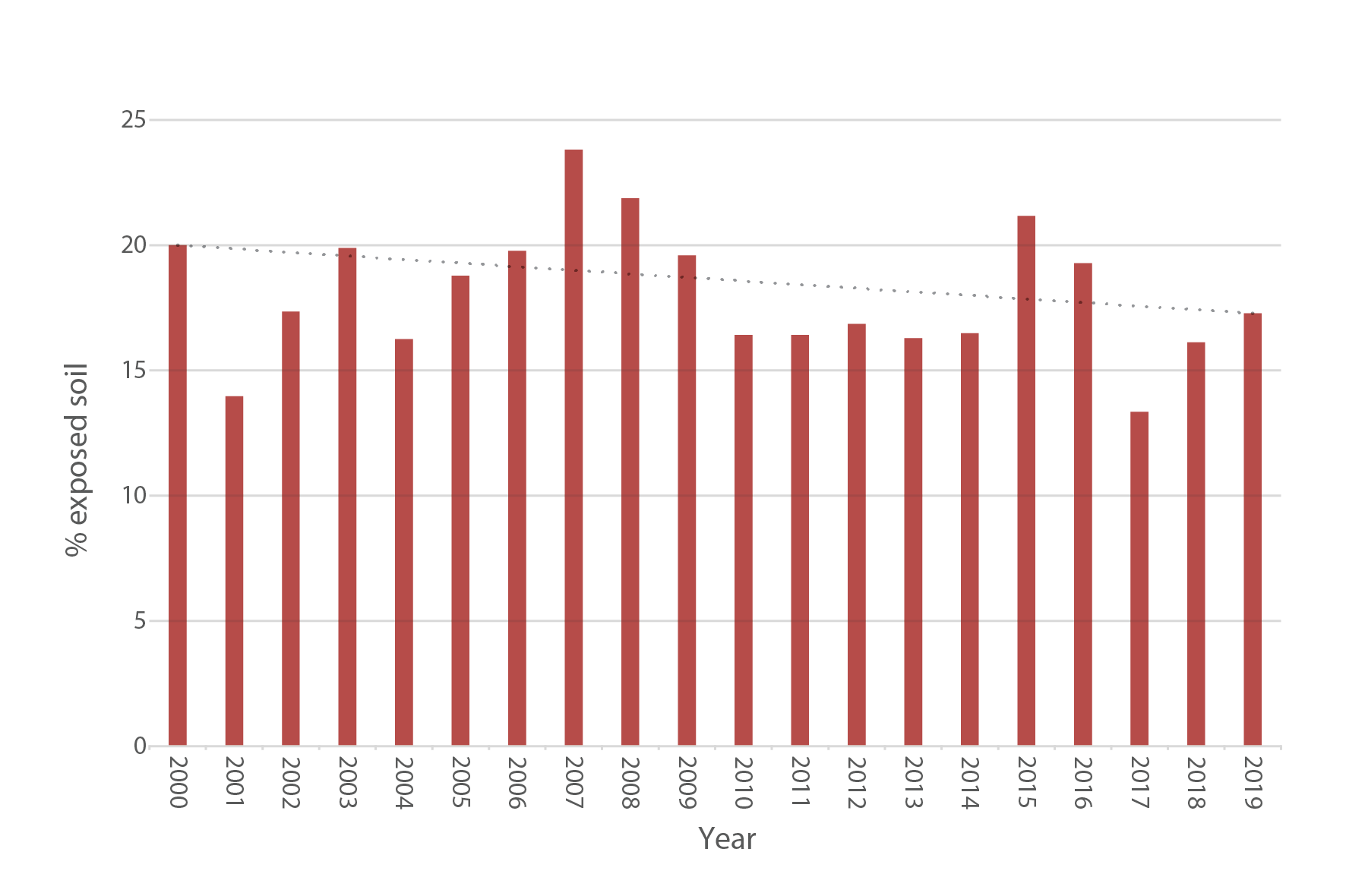
Figure 12: Annual percentage of exposed soil in the Wimmera over time(29)
There is a positive and increasing trend towards minimum tillage cropping practices, and an increase in retaining adequate ground cover across the farming landscape. There are also some seasons where decreases in this positive trajectory are observed.(26) This is largely due to seasonal challenges. Increased prevalence of pests such as mice, snails and slugs or increases in stubble biomass and stubble lodging, which makes inter row sowing of crops difficult are some examples. These seasonal challenges are often tackled using historical management practices, particularly stubble burning, leaving bare soil susceptible to erosion, moisture loss and a reduction in organic matter. Further work needs to be undertaken to promote innovation, technology and new approaches to address these seasonal challenges.
Bare ground leaves soil vulnerable to wind and water erosion. National ground cover thresholds have been developed for controlling erosion on agricultural land. The thresholds are 50% cover to control wind erosion and 70% cover to control water erosion.(30) Land management practices are consistently providing ground cover above the required thresholds across most of the catchment.(31) However, satellite mapping has demonstrated that ground cover percentage levels decline in dry years, particularly from November to April when crops have been harvested and over-grazing is more likely to occur. It is likely that predicted climate variability will impact ground cover levels, particularly during droughts and low rainfall occurrences. Ground cover management will be particularly important during these times.
Lack of ground cover can also leave non-agricultural land, including national parks and public reserves, vulnerable to erosion. Bare ground vulnerable to wind and water erosion can result from fire, herbivores such as rabbits, deer and goats, and motorbikes and four wheel drives entering areas and removing vegetation.
The south west Wimmera has a long agricultural history of pastures and grazing. There has been a shift in recent years to also incorporate crops into farming enterprise mixes, which now appears to be stabilising.(25) Data from the 2019 Wimmera Land Use and Land Management Transect Surveys indicates an increase in stubble burning and cultivated fallow practices, which leaves soil vulnerable to erosion.(26)
Use of perennial pastures has continued in the Upper Catchment and can be an effective way of maintaining ground cover and reducing soil erosion. Pasture research will need to continue to reflect the changing needs and challenges faced by farmers. Soil health gains can still be made by increasing the percentage of land with adequate ground cover. Practices such as the use of perennial pastures, fencing waterways, off-stream water points, stubble retention, stock containment areas and rotational grazing are all being used to retain ground cover.
The use of regenerative agricultural practices have been observed in the Wimmera. Regenerative agriculture intends to improve soil health and function, which in turn enhances water quality, vegetation and land productivity. Regenerative farm practices include multi species cover cropping, increased use of organic fertilisers and amendments, as well as a reduction in the use of herbicides, insecticides and fungicides. Research is required to understand the potential benefits and challenges of regenerative farming principles and practices in the Wimmera, given lower rainfall and the need to retain soil moisture.
Some Wimmera soils are naturally acidic. Intensive farm practices, such as the use of nitrogen-based fertilisers, growing legumes in crop rotations and hay production accelerate soil acidification, which can lead to productivity decline. Modelling estimates indicate that the upper catchment, south-west Wimmera and parts of the north-west Wimmera are moderate to high-risk areas for soil acidification, accounting for 53% of Wimmera grazing areas.(32) Anecdotally, there is widespread use of lime to mitigate the impact of soil acidification. Soil pH monitoring has not been completed in Victoria since 1994. Comprehensive testing would be required to assess the current trend in acid soils within the Wimmera.
Sodic soils are naturally widespread in Wimmera subsoils. Dispersion of sodium in the subsoil can cause compaction and water logging, negatively impacting productivity and causing erosion. Testing and treating soils as required can limit decline in productivity and soil structure. Anecdotally, there is widespread use of gypsum to mitigate the impact of soil sodicity. Comprehensive testing would be required to assess the current trend in sodic soils within the Wimmera.
Salt has accumulated naturally in Wimmera subsoils over the last few million years and can remobilise due to rising groundwater levels bringing salt to the surface. Anecdotally dryland salinity appears to have stabilised across the catchment, most likely due to land management measures and the Millennium Drought where subsequent dry years resulted in groundwater levels falling. Waterlogging following drought years may increase the risk of dryland salinity, as groundwater systems recharge. Almost 22,000 hectares, or just over 1% of the region, is visibly affected to some degree by salinity. This includes almost 6,000 hectares of severely impacted land.(33)
Major threats and drivers of change
Exposed soil, leading to wind and water erosion are significant threats to soil health and function in the Wimmera. Erosion negatively impacts soil fertility and productivity, biodiversity values, as well as human health. Bare soil is generally the result of land management practices such as cultivation, stubble burning and over grazing. Bare soil can also occur on public land following fire, overgrazing by herbivores and illegal vehicle activities. Wind erosion is a moderate threat across the catchment. Water erosion is a moderate threat in the Upper catchment and south west Wimmera. Exposed soil is slowly declining due to changed land management practices. A changing climate dominated by a declining average rainfall will likely provide challenging conditions in which to retain ground cover in some years. Continued research and extension will be required to increase and equip the number of land managers with the best tools and techniques to manage ground cover and minimise erosion.
Sub-soil sodicity has the potential to lead to a decline in soil structure, water logging, compaction and agricultural productivity losses. Sub-soil sodicity is considered a moderate threat across the Wimmera catchment.
Soil acidification can be accelerated by agriculture. Acid soils are associated with reduced plant growth and productivity, increases in the impact of toxic elements such as aluminium, and restricted soil biological activity. These impacts can ultimately lead to soil structure decline and erosion. Acid soils are considered a moderate threat in the south west and a high threat in the upper catchment.
Sub soil sodicity and acid soils are naturally occurring in the Wimmera. Monitoring and extension is required to minimise impacts to soil health and function.
The changing climate is a major driver of change in Wimmera land and soils. Climate forecasts predict a decrease in rainfall, along with an increase in temperature. This has implications across agricultural industries as researchers and farmers identify techniques to improve climate resilience into the future.
Support and collaboration between government, industry, research and farmer groups, and public land managers will be required to achieve the long and medium-term outcomes identified for land health.
Land and natural resource managers will be better placed to manage soil health when armed with reliable data. Up to date soil health data is required for physical, chemical and biological parameters across the catchment.
Desired outcomes for the future
Outcomes to be achieved in 20+ years
- Healthy Wimmera soils support productive agriculture and a functioning natural environment.
- The knowledge and experience of First Nations people is informing land planning, management and delivery in the Wimmera.
Outcomes to be achieved in 6 years
- Ongoing collaboration and two way learning in land planning and management by supporting and strengthening partnerships with First Nations people.
- Maintain ground cover at 70% or greater, annually.
- Farmers adapt practices to a changing climate.
- Increase land manager’s knowledge of management practices that contribute to healthy productive soils.
Complementary Plans
Wimmera Carbon Ready Plan
The Wimmera Carbon Ready Plan was developed by Wimmera (CMA) in 2016. It is a strategic planning document for the long-term management of Wimmera soils and other natural assets in the context of adapting to and mitigating the impacts of a changing climate. The plan emphasises the need to continue research and trials that test new ideas and demonstrates these to farmers.
Strong, Innovative, Sustainable: A new strategy for agriculture in Victoria
This ten-year strategy documents Agriculture Victoria’s commitment to work with industry, community and trading partners to ensure that the Victorian agriculture sector is strong, innovative and sustainable.
Grampians Region Climate Adaptation Strategy 2021 – 2022
This plan outlines opportunities, barriers and actions to build resilience to and reduce the risk posed by climate change.
National Soil Strategy
The National Soil Strategy sets out how Australia will value, manage and improve its soil for the next 20 years. The strategy highlights three overarching goals to prioritise soil health, empower soil innovation and stewards and strengthen soil knowledge and capability.